
How to use a compass for orientation and navigation
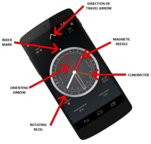
Compass Parts
Before you start using your compass
Each time you open the compass, shake your device a few times around its three axes in order to improve accuracy.
If your phone or tablet is protected by a magnetized cover, remove it before using the compass.
To rotate the compass bezel or orienting arrow, place two fingers on the screen at the same time and perform a rotation gesture.
Adjust the magnetic declination
- Find the current magnetic declination for your location. You can get it from this link.
- Push the Set Declination button.
- Set the magnetic declination by turning the orienting arrow. You can fine tune the declination by activating the Fine Tune mode.
- Push again the Set Declination button to block the orientation arrow.
- You can also long press the Set Declination button to toggle between resetting the declination and getting the default value for your region.
Reset the magnetic declination
For a rapid magnetic declination reset, press and hold the Set Declination button.
Orient a map
- Adjust the magnetic declination if necessary.
- Rotate the bezel so that the north mark aligns with the index mark.
- Place the device on the map so that its edge aligns with the map longitude lines.
- Rotate the device and the map together until the magnetic needle aligns with the orientation arrow. Now your map is aligned with the geographical north.
Take a bearing from a map
- Orient the map.
- Place the device on the map so that its edge aligns with your current location and the location you wish to travel to.
- Rotate the bezel until the orientation arrow aligns with the magnetic needle.
- The direction of travel arrow on the compass gives you your direction of travel.
Find where you are on a map
- Look around and select two distant objects that you can identify on your map.
- Mark the selected objects on the map.
- Orient the map.
- Aim the direction of travel at the first object.
- Rotate the bezel until the orientation arrow aligns with the magnetic needle.
- Place the device on the map and draw a line along its edge through the mark of the first object.
- Repeat from step 4 for the second object.
- The intersection of the two obtained lines gives you your approximate position. If you repeat the process with a third object, the intersection of the three lines will result in a triangle. Your approximate position on the map is inside the triangle.
Measure the slope of the terrain
- Rotate the bezel so that the east or west mark aligns with the index mark.
- Place the device on the ground, aligned with the greatest slope.
- Read the slope value shown by the clinometer needle on the inner scale of the compass.